On Maps & Map Makers
Life Tracks & Trails
I really don’t think I would have survived as an early settler, the whole thing just seems so very difficult. Trudging along unmapped bush tracks, 200 years ago, to places at the ‘end of the known world’ brought with it risks so unfamiliar to us. Frankly, it is hard enough surviving the perversity of this world with a myriad of enticing alternatives, and people of all sorts trying to sway us to follow this way or that, not to mention our own frailty and failures.
So, having a map of life, and for life, seems a fairly reasonable thing to have, and to follow. But having the map doesn’t make things necessarily easier. For a start, the Map has to be believed. It then has to be used with every expectation that the Map Maker knew what he was talking about. We need to trust the message: the pathway and the destination are where they are claimed to be; and, that our journey is safe despite all the difficulties.
But to have and to believe and to do doesn’t come easy, especially when we encounter all sorts of dilemmas along the way; some specific, unexpected events devastate us. Following the Map Maker and his map during and after such times becomes a greater challenge, and not an altogether welcome one. It is a discipline of choice for the One who sets before us His map doesn’t force us, or coerce us into following it. He is gentle and kind and knows us by name.
Map co-ordinates: Isaiah 35:8, 40:27-31; Ezra 7:9; Psalm 18:36; 48:14, 138:7; 142:3; 23:4. Jeremiah 33:3; Luke 24:32. Matthew 11:5.
The Map
Mind muscles stretch from contour to contour,
Soul disappears into symbolism and reality,
Absorbed, following a map's lines and legends.
The will becomes enfolded within the creases,
Delightfully sublimated by wandering; endless
Possibilities, “What could I find in that spot?”
Then, as if from some long-forgotten world,
The Siren calls, “Breakfast is ready!”
Yes, I think, I shall enjoy going there.
Tracks+Trails@Three.am
A Look at Paterson, NSW
To fill in a sleepless night last week an involuntary reflex dragged me off to our National Library’s website. Yeah, I know, sounds rather dreary, but to hang-out at online archives can be rather interesting. I wanted to find maps of the Paterson district. Maps are a longtime favourite of mine, the older the better.
The boon to researchers of government archives is a tremendous opportunity for discovery, especially for those who don’t have a trip to Canberra on their ‘to-do list’. (But, I will add, there is nothing like seeing the real thing). The maps are in colour and one can zoom in and out and get up close and personal. You can save to disk those of interest for further perusing. Well, it’s free and you may as well make the most of it, of anything, at 3am.
One particular crabby-edged but beautiful, old map dated 1820s, of “Roads Northward of Sydney”, caught my attention. In stark contrast with the plethora of land information available nowadays, this map (f436a) shows how little was known of our continent back then. The road weaves up through the Wollemi; in the north it fades out at Burning Hill (past Tamworth). [East] Maitland is clearly marked as a town; Singleton isn’t, but Warkworth is.
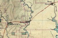
Extract from
NLA map-f436a. c.1820s
What of our little town? From Oakhampton there is but one road coming to our area. Where Paterson is not shown by name the locality of “Barfield” is indicated.
The continuation of this road is noteworthy. It doesn’t go north to Vacy, or Dungog, for neither place is shown. After crossing the river this lonesome road runs first through ‘Brisbane Grove’ and across through ‘Nortenhof’. It then drives east along the far end of Keppies Rd, more or less, crosses Tucker’s Creek and runs up over the hill on its way to Booral, via the locality of Uffington. (i.e. Clarencetown).
Most significantly, this road is the only road north. There is nothing else from Newcastle, or Maitland, or anywhere. If this is, indeed, the only road north, then the early settlers of Patersons Plains witnessed all people and activity associated with the early settlement of The Williams and A.A. Co. land. Paterson, therefore, was a true frontier settlement, and little Keppies Rd, upon which I live, was the major northward highway in the 1820s. Not bad for a dirt track!
WWWhere2go@Three.am
National Library of Aust: http://www.nla.gov.au
NSW State Library. http://www.sl.nsw.gov.au
Australian War Memorial: http://www.awm.gov.au
National Archives of Aust. http://naa12.naa.gov.au


0 Comments:
Post a Comment
<< Home